When we look to the night sky, the stars we see today are much the same as the Oyster Bay people looked up to across tens of thousands of years.
This always was and always will be Aboriginal land.
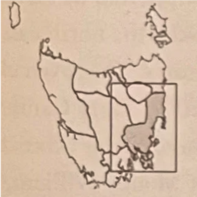
Here we honour the Mumirimina people of the Oyster Bay nation, the first people to share stories of belonging in this place, grounded in an ancient and intrinsic connection to land, waterways, sky and all living things.[1]
Special thanks to Tasmanian Aboriginal Elders, Colleen Mundy minungkana and Cheryl Mundy tremanya[13], who so patiently guide our growing understanding of the world’s oldest continuing culture.
For details, visit our History Rooms, see our Pitt Water Chronicles articles and check out the references listed below.
This information contains names of people who have passed away.
Deep time to dispossession. Resilience, reflection, respect.
| 40,000 years ago… | Different groups of Aboriginal people moved across the vast area that then connected the continental mainland to Lutruwita/Tasmania – during the last Ice Age they were the most southerly living humans in the world.[1] |
| 12,500 years ago… | As the climate warmed, rising seas flooded the area from west to east. The people retreated on both sides of what was to become the Bass Strait. |
| 10,000 years ago… | Glaciers and ice sheets retreated and eventually disappeared. The seas reached present levels, forming the island coastline and isolating Tasmanian Aboriginal people from the rest of humankind for several thousand generations.The Palawa stories of creation changed from the long walk across the Bassian Plain to the pathway in the sky where Ancestral Beings walked across the Milky Way – two stars[2] creating the landscape and all living things. |
| 8000 years ago… | Sea levels reached present day high and low watermarks. Cultural practices continued through the generations. The Mumirimina people of the Oyster Bay tribe fished, gathered and hunted around the beaches, islands, foreshore and hinterland of the present-day Pittwater and Risdon districts. They managed the land with fire, encouraged new growth for the wildlife, kept open pathways that networked from coast to highlands for ease of seasonal movement, maintaining trade and close alliances[3].The Mumirimina tended to move inland later than other bands of the Oyster Bay nation, leaving between September and October and returning to the coast in June. |
| 1642 | Abel Tasman anchored off Marion Bay. Dutch VOC flag planted on shore 3 December. Tasman’s journal described voices heard, campfire smoke and cuts in trees: “…heard certain human sounds…though they had seen no one.” |
| 1772 | French explorer Captain Nicholas Marion du Fresne anchored in North Bay (Frederick Henry Bay). |
| 1772/73 | French explorer Bruni D’Entrecasteaux sailed into Frederick Henry Bay. |
| 1798 | British explorers George Bass and Matthew Flinders in Frederick Henry Bay. |
| 1802 | French explorer Nicholas Baudin in Frederick Henry Bay. M. Faure charts and names Carlton River (Riviere Brue) and Pitt Water (Basin Ransonnet). |
| 1803 | Colonial surveyor James Meehan passed through Mumirimina lands, mapping the good soil, fresh water and potential for farming. Meehan met some Tasmanian Aboriginal people, once firing on a group when he felt threatened.[4] |
| 1805 | George Prideaux Harris surveyed the Pitt Water district. |
| 1806 | First farms in cultivation in Gloucestor, as Sorell District was then known. |
| 1809 | Mumirimina man John Shinal (Shiney, Aboriginal name unknown) was born in the Carlton area. He lived a tribal life with his family until land grants in that area from 1812, then was ‘taken in’[5] by a settler family and later worked as a farm labourer. |
| 1812 | First land grants confirmed by Governor Macquarie. |
| 1815-19 | An Aboriginal ‘mob’ traversed between Risdon and Pitt Water in the summer and retired to the east coast in winter, including a camp at Sweetwater Hills at Penna. |
| 1817-22 | 40th Regiment stationed in Pitt Water/Sorell. |
| 1819 | Pitt Water township established – nine residents, 60 farms. |
| 1821 | Governor Macquarie visited Pitt Water. He named the town Sorell in honour of the Tasmanian Governor. First school built; headmaster Charles Hippesley Cox (57 students). Courthouse and gaol built and first public houses licensed. |
| 1825-1831 | The dispossession of the Mumirimina had been early, violent and rapid,[6] then between 1825 and 1831 the Frontier War became a horrifying and brutal guerrilla war of attrition.[7] |
| 1826 | Military barracks and a watch house built at Sorell.On 9 December, fourteen Oyster Bay people believed killed and nine others, including Kickerterpoller, were captured and lodged in the Sorell gaol.[8] |
| 1827-30 | Increasing conflict with Aboriginal people throughout the district. In 1828 Governor Arthur declares martial law against the Aboriginal people in the Settled Districts.[9] |
| 1829 | In June a band of Oyster Bay and Big River warriors led by Tongerlongeter[10] attacked Carlton River settlements. |
| 1830-31 | Sorell settlers took part in the Black Line[11]. Governor Arthur at Sorell during the operation. Settlers signed a letter of thanks. |
| 1832 | The remaining Oyster Bay and Big River people (16 men, 9 women and a child) walked into Hobart Town. Lead by Tongerlongter and Montpeliater, they met the Governor on 7 January 1832 and 10 days later were exiled to Flinders Island.[12] |
| 1836 | Governor Arthur proclaimed the County of Pembroke, including Pittwater, the Sorell township, the Tasman Peninsula and north to Little Swanport River. |
| 1834 | Fanny Smith[13] was born at Wybalenna on Flinders Island to Tanganuturra from Musselroe and Nicermenic from Robbins Island. |
| 1839 | On his death, Mumirimina man John Shinal’s body is mutilated and his severed head preserved in alcohol. |
| 1847 | The last 47 of the Palawa exiled at Wybalenna on Flinders Island were removed to Oyster Cove. |
| 1854 | Fanny Cochran married[14] William Smith and they had 11 children; many of the Tasmanian Aboriginal community are their descendants.[15] |
| 1858 | Mumirimina warrior Kalamaruwinya was photographed several times at Oyster Cove, two years before he died. |
| 1899 & 1903 | Fanny Smith recorded Tasmanian Aboriginal songs and language. In 2017 the 1899 and 1903 wax cylinder recordings were inscribed into the UNESCO Australian Memory of the World Register. |
| 1967 | Aboriginal Tasmanians were formally counted in the national census for the first time[16] |
| 1990 | John Shinall’s remains were returned from Dublin University to the Tasmanian Aboriginal community and buried on Mumirimina country[17]. |
| 1995 | First used in 1971, the Aboriginal Flag along with the Torres Strait Islander Flag are proclaimed ‘Flags of Australia’ under the Flags Act 1953. |
| c2012 | Mumirimina signs at Sorell Rivulet and Blue Lagoon at Dodges Ferry. |
| 2015 | Sorell Council policy recognises the Mumirimina as Traditional Owners.[18] |
| 2016 | The Tasmanian Constitution is amended to acknowledge the Tasmanian Aboriginal people as Tasmania’s First People and the traditional and original owners of Tasmanian land and waters.[19] |
| 2020 | The Aboriginal flag flies at the entrance to Sorell Council on a permanent basis. |
| 2022 | The black cockatoo officially adopted as Sorell School’s new logo. |
| 2024 | From July, Sorell Council monthly meetings begin with a statement acknowledging the Mumirimina and the Tasmanian Aboriginal community. |
| 2025 | Sorell School redevelopment includes the black cockatoos logo and the mina nina krakani building (palawa kani for “me you sit together”) officially opens.[20] The new Steiner School at Carlton is officially gifted the name ‘Nipakawa’, a palawa kani word meaning ‘wave’.[21] |
| Today | Palawa culture and stewardship continues the enduring connection to lands, waterways, skies and community across thousands of generations. |
References
[1] Reconciliation Tasmania timeline
[2] Journal of Astronomical History and Heritage, 19(3), 327– 347 (2016): “Aboriginal Tasmanians spoke of the subject of stars with great zest.” (George Augustus Robinson, 13 March 1834).
[3] Patsy Cameron, Aboriginal Life Pre-Invasion, www.utas.edu.au/tasmanian-companion/biogs/E000015b.htm
[4] Dr Imogen Wegman, How early Australian settlers drew maps to erase Indigenous people, The Conversation, 31 May 2021
[5] Lyndall Ryan, Tasmanian Aborigines: A History since 1803, Allen & Unwin, 2012, p69
[6] takara limuna (Sheoak Walk) interpretation, Clarence City Council, 2023
[7] Lyndall Ryan, Noted works: The Black War, The Conversation, 6 August 2014
[8] Lyndall Ryan, Tasmanian Aborigines: A History since 1803, Allen & Unwin, 2012
[9] Tasmanian Aboriginal Centre, Mumirimina people of the Lower Jordan River Valley, tacinc.com.au, 2012
[10] Henry Reynolds & Nicholas Clements, Tongerlongeter: First Nations Leader & Tasmanian War Hero, NewSouth Publishing, 2021, p123
[11] Nicholas Clements, The Black War, Queensland University Press, 2014 and Julie Gough, Tense Past, Tebrikunna Press, 2021
[12] Reconciliation Tasmania timeline
[13] Artist statements, taypani milaythina-tu Return to Country, TMAG, 2022. Fanny Smith was Colleen & Cheryl Mundy’s great-great-grandmother.
[14] theorb.tas.gov.au, Fanny’s Timeline, accessed 1/12/2025
[15] Warner, McCormack and Kurnadi, Pathway to Truth-telling and Treaty, DPAC, 2021
[16] Russell Taylor, The 1967 Referendum and Today, Parliament of Australia, 26 May 2017
[17] Cheryl Mundy, personal communication, 2025
[18] Sorell Council, Acknowledgement of Traditional Owners Policy, 2015 & 2019
[19] Constitutional Recognition of Tasmanian Aboriginal people, dpac.tas.gov.au, accessed 1/12/2025
[20] Media Release, premier.tas.gov.au 26/5/2025
[21] nipakawa.tas.edu.au, accessed 1/12/2025